
Wigwam Bay Coastal Wetland Restoration Project
Arenac County, MI
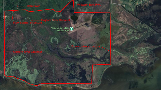
Figure 1. Site location for Wigwam Bay SWA coastal wetland and impoundment of Lake Huron.
Located adjacent to Lake Huron's Saginaw Bay, the Wigwam Bay State Wildlife Area (SWA) spans approximately 3,500 acres and consists of 3,137 acres of coastal wetlands, about 900 acres of which are impounded, adjacent to Saginaw Bay of Lake Huron. The impounded unit is situated at the mouth of the original Rifle River; however, the river was diverted through a channel to the west of the mouth and around the western outer edge of the unit in the late 1800s to support lumber mill operations. The area was subsequently diked in 1933 to support commercial muskrat production. The existing impounded unit has no hydraulic connectivity with the Rifle River or Saginaw Bay and provides limited benefits to water quality, flood reduction risks, and fish production which would help to meet Lake Huron Committee fish community objectives. There are gravity flow gates on the northwest and southeast corners of the unit. However, water levels within unit are heavily influenced by conditions in Saginaw Bay and the Rifle River, resulting in limited water level control. The old Rifle River channel still exists within the impounded unit. High water levels or seiche events from outside the unit impact internal water levels. Additionally, the existing gravity drain gates are highly degraded and lack full functionality, consequently, there is limited connectivity from the Rifle River and Saginaw Bay during high water levels to promote fish production in the unit and historic river channel. Additionally, the lack of water level control restricts Michigan Department of Natural Resources (MDNR) managers' ability to periodically use water management techniques to control potential dense stands of invasive hybrid cattail and Phragmites.
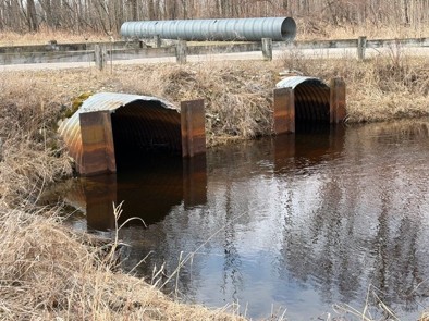
Figure 2. Existing Rifle River infrastructure on the west side of the Wigwam Bay SWA impoundment. The culverts are under the road grade in the channelized portion of Rifle River.
The overarching goal of this project is to improve hydrological connectivity of the impounded area, increase access for important fish species of common concern for the Lake Huron Committee, enhance water level management as an invasive species (plant) control technique, and promote native vegetation growth in Wigwam Bay SWA. This project supports the restoration of critical habitats for fish and wildlife, including state-threated species such as lake sturgeon and black tern. Additionally, the improved wetland habitats will benefit other key fish species like yellow perch, northern pike, and walleye, by providing essential spawning and nursery habitat. The project also addresses the Lake Huron Committee's Environmental Priorities focused on habitat connectivity, particularly for fish production, by restoring connected coastal wetlands, facilitating fish passage, and improving wetland spawning and nursery habitats in Saginaw Bay. It aligns with other regional priorities such as the Lake Huron Lakewide Action and Management Plan. and the Lake Huron Biodiversity Conservation Strategy for reducing nutrient loading to Saginaw Bay and Audubon's Vision: Restoring the Great Lakes for Birds and People, mitigating the impacts of invasive species, ensuring that this restoration effort contributes to the broader goal of sustaining healthy and resilient ecosystems in Lake Huron. The proposed project will also yield significant community benefits in creating diverse opportunities for outdoor activities, such as birdwatching, fishing, hunting, and paddling, which all contribute to the local economy.
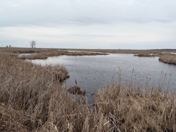
Figure 3. Historic Rifle River channel inside of Wigwam Bay SWA impoundment (looking east from outlet) with invasive hybrid cattails on channel margin.
This project will consist of a feasibility study that will evaluate hydrological and geotechnical factors to explore enhancing connectivity of Wigwam Bay SWA with the Rifle River and Saginaw Bay, while improving vegetative communities and habitat for other species including waterfowl and secretive marsh birds (terns) in the area. Extensive physical (topography and bathymetry) and biological assessment surveys for fish, water quality, and avian communities will be conducted as a part of the feasibility study. Outcomes and recommendations resulting from this feasibility study will be used to complete conceptual design plans to facilitate implementation as a part of subsequent phases of this project. MDNR fisheries staff will be integrally involved in feasibility and design elements to ensure design elements enhance fish production through improved fish access and habitat connectivity between the river, impounded unit, and surrounding areas, directly benefiting aquatic species. Other project team members will contribute expertise to developing plans to enhance wetland wildlife including secretive marsh birds and waterfowl and to enhance water quality in the area and Saginaw Bay
The feasibility study will be completed with the development of a full report in Fiscal Year 2028. Current funding levels will support both feasibility study development and concept level design plans to achieve project objectives. Following completion of the feasibility study and concept design development, additional funding sources will be sought out to complete the design and implementation. Because the funds requested are for feasibility/design, a NOAA Tier 1 monitoring plan has been developed prior to implementation of the feasibility study detailing pre-restoration data collection requirements, with input and assistance from NOAA staff as needed. All data collection will adhere to the Quality Assurance Project Plan. Significant pre-restoration monitoring and assessment as a part of the Audubon Great Lakes “Restoring Wigwam Bay for Breeding Marsh Birds – 2018-2021 Report & Conservation Action Plan” has been developed and will be used for developing future monitoring plans. MDNR will assist in the development of fish community assessment monitoring plans.
Project partners include National Oceanic and Atmospheric Administration (NOAA), Great Lakes Fishery Commission (GLFC), Audubon Great Lakes (AGL), Michigan Department of Natural Resources (MDNR), and Department of Environment, Great Lakes, and Energy, Michigan (EGLE) and Saginaw-Chippewa Indian Tribe (SCIT). Project partners expect that with the cooperative agreement in place, NOAA will partner with the project team and will remain substantially involved throughout the award period. Assistance with feasibility study design development, including stakeholder engagement, and engineering and design elements is expected.
The physical data pre- and post-construction will be stored internally by MDNR, AGL, and the GLFC on this webpage as well as on the Wigwam Bay Data Portal. All data on the portal should be considered provisional. Contact Jeff Tyson for more information or to make a data request. All future sub-awardees not identified in this plan will have acceptance as a condition of their contract of this data sharing plan. Any additional data sharing stipulations for future sub-awardees may be outlined at that time and described in their contract.