
Towpath Park Coastal Shoreline Restoration Project
Lucas County, Ohio
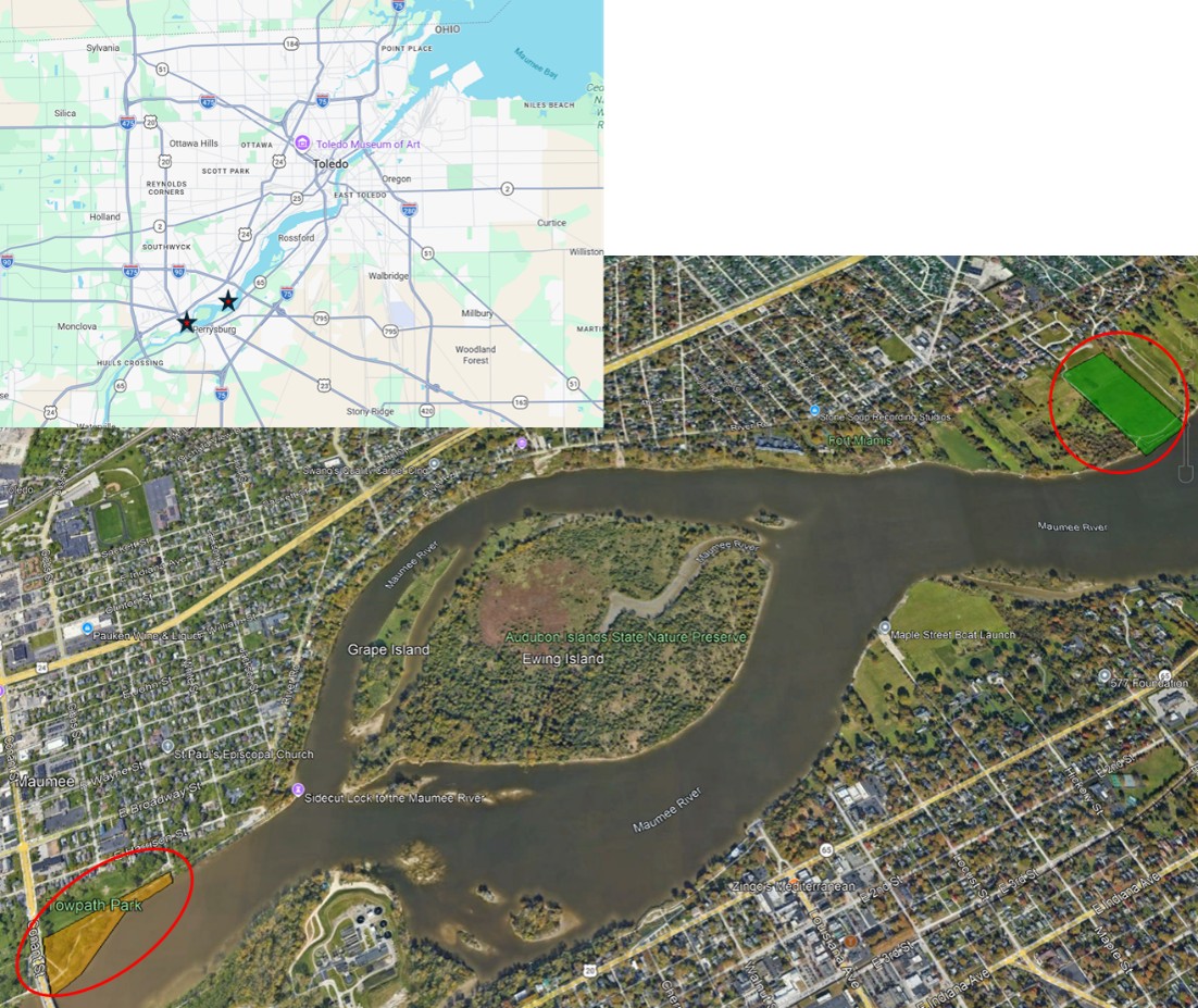
Figure 1. Site location for Klewer Towpath Park and River Bend restoration sites, Maumee, OH.
Much of the lower Maumee River shoreline has been modified through structure addition/infilling, reducing the amount of side channel and connected floodplain habitat, submerged aquatic vegetation, and habitat heterogeneity. This reduces the amount of quality habitat available as larval nursery areas for multiple Lake Erie priority fish species, including ecologically and economically important walleye, and white bass. The project location is directly adjacent to significant walleye and white bass spawning habitats in the Maumee River (Jerome Rapids) and is expected to increase the extent of larval nursery habitat and increase larval survival for these as well as other species which are currently undergoing restoration. The Maumee River also has ongoing lake sturgeon and sauger restoration, with juvenile lake sturgeon stocking being implemented by the Toledo Zoo, US Fish and Wildlife Service, and Ohio Department of Natural Resources (ODNR) and sauger stocking being implemented by ODNR.
Project objectives include restoring habitat quality and connectivity among within two sites in the Maumee River, creating additional larval and juvenile nursery habitat for walleye and other native fishes, restoration of wetlands and connected floodplain habitat, nutrient and sediment sequestration, and connecting the local communities with the river through outdoor classroom opportunities or other park uses. The project will ultimately provide recreational and commercial fishery benefits and move the LEC closer to the achievement of its fish community objectives, particularly through the expected impacts on walleye and white bass production from the Maumee River system and incrementally enhance lake sturgeon and sauger restoration in Lake Erie. Additionally, the project will provide outdoor classroom opportunities for the Maumee City Schools, which has facilities located adjacent to the restoration sites.
The proposed project will implement restoration measures identified in Detailed Project Report and Environmental Assessment – Klewer Towpath Park and Maumee River Aquatic Ecosystem Restoration including creation of off-channel connected coastal wetlands and floodplain reconnection, increase habitat heterogeneity through placement of coarse woody debris (locked log and root wad structures) and gravel bar restoration, and reduce sediment and nutrient loads to western Lake Erie as developed by US Army Corps of Engineers (USACE) . As part of the Feasibility Study, USACE and the project team have completed development of a focused array of alternatives, initial NEPA scoping and tribal coordination, Phase 1 archeological survey, habitat evaluation and wetland delineation, community outreach, and developed concept-level plans for three sites in the vicinity of Conant Street, Maumee, Ohio. The two sites identified for restoration include the Klewer Towpath site, just downstream of the Conant Street bridge, and the River Bend site, just downstream of Audubon Islands (Figure 1).
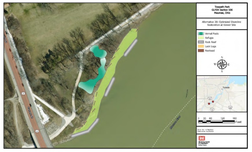
Figure 2. Proposed shoreline habitat restoration at Klewer Towpath Park site (41.5591N, -083.6505W).
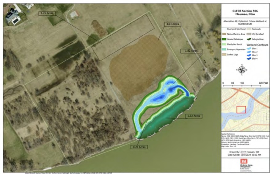
Figure 3. Proposed shoreline habitat and oxbow wetland restoration at Riverbend site (41.5738N, -083.6151W).
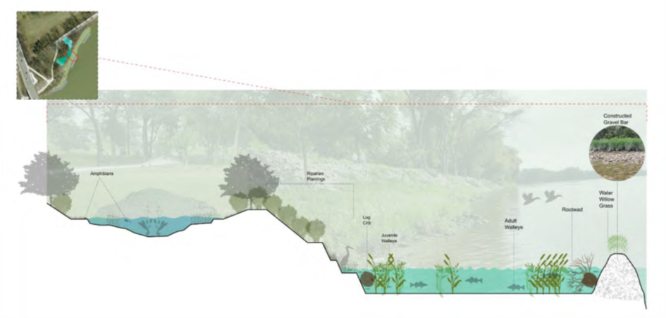
Figure 4. Conceptual cross section showing proposed shoreline and vernal pool restoration measures at Klewer Towpath Park Site.
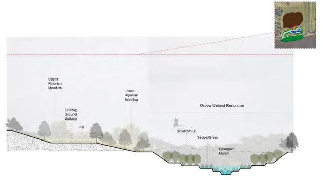
Figure 5. Conceptual cross section of oxbow wetland at Riverbend Site.
The proposed actions at the restoration sites include construction of an ~6.8 acre connected Oxbow wetland (River Bend), shoreline softening/bank cutbacks on 1,800’ of shoreline (River Bend and Klewer Towpath), restoration of 2,200’ of gravel bars (River Bend and Klewer Towpath) and installation of log crib, locked log, and rootwad structures (River Bend and Klewer Towpath) (Figures 2-5). These restoration measures will create functionally connected habitat that will benefit larval walleye, white bass, lake sturgeon, and other priority species in the Maumee River system. Additionally, the floodplain and connected coastal wetland features will reduce nutrient and sediment loads, particularly during high flow events, to western Lake Erie, which currently fuels annual harmful algal blooms. The proposed restoration sites are adjacent to another shoreline and in-water habitat restoration project at Audubon Islands Nature Preserve lead by Metroparks Toledo.
The planned timeline includes development of 60% and 90% design plans and permitting at both sites (Klewer Towpath, and River Bend) for proposed restoration measures during FY26/27 with funding provided by the GLFC. Funding for construction at both sites has been requested for FY27/28. Construction funding request includes funds for floodplain reconnection, in-stream habitat restoration, and vernal pool/wetland creation. Permitting has been initiated and will be completed in conjunction with design and in collaboration with NOAA technical monitors.
As-built surveys (e.g., bank layback, vernal pool and wetland excavation, locked log/log crib placement, gravel bar construction) will be conducted once construction is complete. Photo monitoring at proposed sites will also be included. Previous site assessments conducted by UT/MAAC will be used as pre-site assessments for fish community composition and diversity will be used as pre-site assessment information. ODNR will continue seasonal creel assessments in the area as a part of project assessment and monitoring.
Project partners expect that with the cooperative agreement in place, NOAA will partner with grantees and will remain substantially involved throughout the award period. Assistance with stakeholder engagement, engineering and design, permitting, and construction is expected. Project partners include The City of Maumee, Ohio Department of Natural Resources, Maumee City Schools, and the Great Lakes Fishery Commission.
The physical data pre- and post-construction will be stored internally by Ohio DNR, the City of Maumee, as well as on this website. The data will be available to the public on this website or upon request within 60 days of data validation and entry. All products and data will be available upon request within 2 years of project completion.
Contact Jeff Tyson for more information or to make a data request. All future sub-awardees not identified in this plan will have acceptance as a condition of their contract of this data sharing plan. Any additional data sharing stipulations for future sub-awardees may be outlined at that time and described in their contract.